
Capital Region weather can take a severe turn fast. Our alert system will keep you informed when that happens. On a First Warning Alert Day, everything you need to prepare will be front and center.
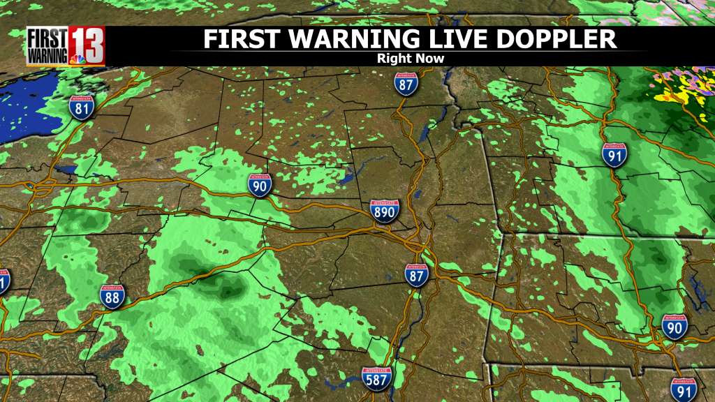
Cloudy and damp for the rest of the day today with areas of fog and drizzle into the evening. Temperatures will hold in the 40s through sunset. Scattered showers will become more common tonight, with steadier rain developing overnight. It will stay relatively mold with lows will be in the upper 30s and lower 40s.
Tomorrow the last wave of low pressure will move through, bringing more steady and at times heavy rain during the day with highs in the lower 50s. With mild temperatures, melting snow and an event total rainfall ranging between 1-3 inches, some localized flooding is possible. Colder air will flow in behind this system which will turn rain to snow across higher elevations Wednesday evening. Valleys could see a light coat of snow overnight with a couple of inches possible in the hills and mountains.
It will be breezy and much colder on Thursday with scattered snow showers and wind gusts as high as 30mph. Highs will be in the 30s. Friday will be dry but cold with mostly sunny skies and highs near 30.
Have a great afternoon!
SEVERE THUNDERSTORMS
WATCH VS. WARNING
Do you know the difference between a National Weather Service Severe Thunderstorm Watch and a Severe Thunderstorm Warning? Check your knowledge below.
Severe Thunderstorm Watch: Be Prepared! Severe thunderstorms are possible in and near the watch area. Stay informed and be ready to act if a severe thunderstorm warning is issued. The watch area is typically large, covering numerous counties or even states.
Severe Thunderstorm Warning: Take Action! Severe weather has been reported by spotters or indicated by radar. Warnings indicate imminent danger to life and property. Take shelter in a substantial building. Get out of mobile homes that can blow over in high winds. Warnings typically encompass a much smaller area (around the size of a city or small county) that may be impacted by a large hail or damaging wind identified by an NWS forecaster on radar or by a trained spotter/law enforcement who is watching the storm.
HOW TO PREPARE AT HOME
The top priority is getting inside a sturdy building, and moving away from windows. This would keep you safer from any damage from the wind or hail. With most severe thunderstorms, it is not necessary to head to a designated storm shelter. However, with the more destructive storms, it would be smart to treat it like a tornado and head to a safe place in your home or business.
Keep your cell phone charged and have the WNYT First Warning Weather app downloaded so that you can keep up with the latest watches and warnings for your area.
HOW TO PREPARE IF OUTSIDE OR AWAY FROM HOME
Thunderstorms can produce damage similar to that of tornadoes. For that reason, you should protect yourself from severe thunderstorms as you would when a tornado approaches. Always try to get to a sturdy building. An interior room on the lowest floor of that building is usually the safest. Always remember to stay away from windows.
If you are stuck outside, remember to crouch down in a low area away from tall, individual trees. Lightning is attracted to tall objects. If you’re caught in a severe thunderstorm while driving, slow down and get off of heavily-traveled roads. If possible, find a sturdy structure to get indoors. Your car does offer a certain amount of protection from lightning, so stay inside if there are no buildings available close by.
FLOODING
WATCH VS. WARNING
What is the difference between a Flood Watch and a Flood Warning issued by the National Weather Service?
Flash Flood Warning: Take Action! A Flash Flood Warning is issued when a flash flood is imminent or occurring. If you are in a flood prone area move immediately to high ground. A flash flood is a sudden violent flood that can take from minutes to hours to develop. It is even possible to experience a flash flood in areas not immediately receiving rain.
Flood Warning: Take Action! A Flood Warning is issued when the hazardous weather event is imminent or already happening. A Flood Warning is issued when flooding is imminent or occurring.
Flood Watch: Be Prepared: A Flood Watch is issued when conditions are favorable for a specific hazardous weather event to occur. A Flood Watch is issued when conditions are favorable for flooding. It does not mean flooding will occur, but it is possible.
Flood Advisory: Be Aware: An Flood Advisory is issued when a specific weather event that is forecast to occur may become a nuisance. A Flood Advisory is issued when flooding is not expected to be bad enough to issue a warning. However, it may cause significant inconvenience, and if caution is not exercised, it could lead to situations that may threaten life and/or property.
HOW TO PREPARE AT HOME
- If you have access to sandbags or other materials, use them to protect your home from floodwaters if you have sufficient time to do so. Filling sandbags can take more time than you may think.
- Have a professional install check-valves in plumbing to prevent floodwaters from backing up into the drains of your home. Make sure your sump pump is working and consider having a backup. Make sure your electric circuit breakers, or fuses, are clearly marked for each area of your home.
- Since standard homeowners insurance doesn’t cover flooding, ensure coverage by contacting your insurance company or agent to purchase flood insurance. This must be done before there is even a threat of flooding, as insurance companies stop issuing policies if there is a threat of flooding. (i.e. an approaching hurricane). Many flood insurance policies take at least 30 days to go into effect, so even if you can buy it as a storm is approaching, it may not protect your investment.
HOW TO PREPARE IF OUTSIDE OR AWAY FROM HOME
Turn Around Don’t Drown! Each year, more deaths occur due to flooding than from any other thunderstorm related hazard. The Centers for Disease Control and Prevention report that over half of all flood-related drownings occur when a vehicle is driven into hazardous flood water. The next highest percentage of flood-related deaths is due to walking into or near flood waters. People underestimate the force and power of water. Many of the deaths occur in cars swept downstream. Many of these drownings are preventable. Never drive around the barriers blocking a flooded road. The road may have collapsed under that water. A mere 6 inches of fast-moving flood water can knock over an adult. It takes just 12 inches of rushing water to carry away most cars and just 2 feet of rushing water can carry away SUVs and trucks. It is NEVER safe to drive or walk into flood waters.
AGENCIES ON FLOODING
Here are a series of resources to help prepare for flooding, to locate assistance and to find or provide aid:
TORNADO
WATCH VS. WARNING
What is the difference between a Tornado Watch and a Tornado Warning issued by the National Weather Service?
Tornado Watch: Be Prepared! Tornadoes are possible in and near the watch area. Review and discuss your emergency plans and check supplies and your safe room. Be ready to act quickly if a warning is issued or you suspect a tornado is approaching. Acting early helps to save lives! Watches are issued by the Storm Prediction Center for counties where tornadoes may occur. The watch area is typically large, covering numerous counties or even states.
Tornado Warning: Take Action! A tornado has been sighted or indicated by weather radar. There is imminent danger to life and property. Move to an interior room on the lowest floor of a sturdy building. Avoid windows. If in a mobile home, a vehicle, or outdoors, move to the closest substantial shelter and protect yourself from flying debris. Warnings are issued by your local forecast office. Warnings typically encompass a much smaller area (around the size of a city or small county) that may be impacted by a tornado identified by a forecaster on radar or by a trained spotter/law enforcement who is watching the storm.
HOW TO PREPARE AT HOME
Continue to listen to local news or a NOAA Weather Radio. Keep your cell phone charged and download the WNYT First Warning Weather app to stay updated about tornado watches and warnings.
If you are in a tornado warning, go to your basement, safe room, or an interior room away from windows. Don’t forget pets if time allows.
HOW TO PREPARE IF OUTSIDE OR AWAY FROM HOME
Seek shelter inside a sturdy building immediately if a tornado is approaching. Sheds and storage facilities are not safe. Neither is a mobile home or tent. If you have time, get to a safe building.
Being in a vehicle during a tornado is not safe. The best course of action is to drive to the closest shelter. If you are unable to make it to a safe shelter, either get down in your car and cover your head, or abandon your car and seek shelter in a low-lying area such as a ditch or ravine.
HEAT
WATCH VS. WARNING
Excessive Heat Warning—Take Action! An Excessive Heat Warning is issued within 12 hours of the onset of extremely dangerous heat conditions. The general rule of thumb for this Warning is when the maximum heat index temperature is expected to be 105° or higher for at least 2 days and nighttime air temperatures will not drop below 75°; however, these criteria vary across the country, especially for areas not used to extreme heat conditions. If you don’t take precautions immediately when conditions are extreme, you may become seriously ill or even die.
Excessive Heat Watches—Be Prepared! Heat watches are issued when conditions are favorable for an excessive heat event in the next 24 to 72 hours. A Watch is used when the risk of a heat wave has increased, but its occurrence and timing is still uncertain.
Heat Advisory—Take Action! A Heat Advisory is issued within 12 hours of the onset of extremely dangerous heat conditions. The general rule of thumb for this Advisory is when the maximum heat index temperature is expected to be 100° or higher for at least 2 days, and nighttime air temperatures will not drop below 75°; however, these criteria vary across the country, especially for areas that are not used to dangerous heat conditions. Take precautions to avoid heat illness. If you don’t take precautions, you may become seriously ill or even die.
Excessive Heat Outlooks—Be Aware! The outlooks are issued when the potential exists for an excessive heat event in the next 3-7 days. An Outlook provides information to those who need considerable lead-time to prepare for the event.
HOW TO PREPARE AT HOME
Drink plenty of water and eat cool, easy-to-digest foods such as fruit or salads while inside. Take a cool bath or shower. Use air conditioners or spend time in air-conditioned locations. Do not direct the flow of portable electric fans toward you if the room’s temperature is over 90 degrees; the blowing air is more likely to dehydrate you faster. Make sure rooms are well vented.
HOW TO PREPARE OUTSIDE OR AWAY FROM HOME
If you must go out during excessive heat events, dress in lightweight, loose clothing that reflects heat and sunlight. Drink plenty of water and minimize exposure to the sun. Children, seniors, and anyone with underlying health conditions should stay in the coolest places available to them. Do not leave valuable electronic equipment in hot vehicles.